Imber is one of those names that tugs at the edges of British memory—familiar yet slightly elusive. Set high on the chalk of Salisbury Plain in Wiltshire, it is a village without villagers, a settlement whose lanes and hedgebanks remain but whose everyday life stopped abruptly in the winter of 1943. Since then, Imber has been part of the Salisbury Plain Training Area, its cottages and streets given over to military training. For most of the year the place is closed, its roads barred by red flags and warning signs. Yet at certain times, gates open, buses run, a church door swings wide, and visitors wander through a place that is at once ordinary and haunting. This article traces Imber’s deeper past, the story of its sudden evacuation, what survives today, and how the village sits within the wider landscape and memory of the Plain.

A Chalkland Setting
Salisbury Plain is a broad plateau of Cretaceous chalk, its open skies and rolling downland famous for prehistoric monuments, sheep walks and, in the modern era, the largest military training estate in the United Kingdom. Imber lies near the centre of this terrain, roughly equidistant from Warminster and Lavington, tucked into a shallow coombe with fields and trackways radiating from its core. Before the twentieth century, its location was both a blessing and a limitation. The chalk drains quickly, making the ground firm and workable for much of the year, but water is scarce and agriculture requires skill, patience and a close knowledge of the land. This landscape bred small, tight-knit communities with mixed farming economies, supplemented by seasonal labour and the rural trades that keep such places going.

Early History and Parish Life
Like many Wiltshire settlements, Imber’s origins are medieval, likely with earlier roots suggested by field systems and the pattern of ancient trackways. By the thirteenth century a parish church—St Giles—stood at the heart of a modest but resilient village. Over the centuries, Imber appears in ecclesiastical records, manorial surveys and poor law accounts that paint a familiar picture of rural English life: the turn of the seasons, births and burials inscribed in registers, disputes over grazing rights, and occasional repairs to the church roof after a storm.
The village was never large. Populations fluctuated with the fortunes of harvests, enclosures and employment. In the nineteenth century, Imber’s families worked smallholdings, served on the larger farms and found income in crafts such as carpentry and smithing. A school and a public house provided the social infrastructure one expects in a parish of this scale, and the lanes that linked Imber to its neighbours, though often rough under wheel, ensured a steady flow of goods, news and marriages. Despite the Plain’s relative isolation, this was not a hermit settlement but one sewn into the ordinary fabric of rural Wiltshire.

The Military Arrives on the Plain
The British Army began acquiring land on Salisbury Plain in the late nineteenth and early twentieth centuries. The breezy openness of the downs, the sparseness of woodland and the low density of settlement made ideal conditions for manoeuvres and live firing. Over decades, farms were bought, rights negotiated and ranges laid out, but pockets of civilian life continued within and alongside the training area. Imber was one of these pockets, its inhabitants living in proximity to an increasingly military landscape. Military traffic passed through; warning notices sprouted on the verges; gunners’ thunder rolled across the downland. Yet village life went on.
The 1943 Evacuation
Everything changed in December 1943. With the Second World War at its height and preparations for the invasion of occupied Europe intensifying, the War Office required larger, more flexible training areas for infantry and armour. Imber, close to existing ranges, was selected as a site for urban and street-fighting training. The villagers were given formal notice to leave. The deadline was rapid—measured in weeks, not months—so the process was abrupt and deeply painful. People packed their belongings, found lodgings across Wiltshire and beyond, and shut cottage doors they believed they would one day open again.
Much has been written about that winter: the trucks loading furniture, the last services in St Giles, the farewells scratched into memory more than into paper. The promise, or at least the strong impression, that the village would be returned after the war lingered in the minds of those displaced. But when peace came, the strategic value of the training estate had only grown. The Army’s case prevailed, and the villagers were not permitted to resettle. Through the 1950s and into the 1960s, public inquiries and campaigns attempted to reverse that decision. The outcome fixed Imber’s fate as a place within the range, not a place to be lived in again.

A Village Preserved by Absence
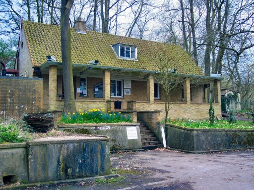
Imber today is a curious sight. Some original buildings remain, though many suffered from neglect, weathering and the hard realities of being in an operational training area. Others were adapted or replaced by plain, blocky structures intended to simulate modern urban environments for soldiers to practise in. The street plan is still legible, with the main thoroughfare stretching through the settlement and lanes curling off to former farmsteads. You can stand at a junction and imagine the sound of hooves and cart wheels, then look up to see a training façade with stencil numbers where sash windows once opened to the wind.
The most eloquent survivor is St Giles Church. Medieval in origin and altered over centuries, it stands within its walled churchyard among yews and gravestones, an anchor of continuity in a place whose social world was severed. The church is no longer a regular parish centre but it has been conserved, its fabric cared for, and at certain open periods its interior can be visited. The chancel arch and nave, the timber roofs and memorial tablets, the traces of old wall painting and the sift of light onto stone all testify to a community that tended and inhabited it for generations. To step inside is to feel the gap between a living village and a preserved one.
Elsewhere in the village, the outlines of cottages, the shell of the former pub, the old school site, and various farm buildings give a sense of domestic rhythm. What remains is neither a museum nor a ruin in the romantic sense. It is a working training landscape populated by the ghosts of vernacular architecture, periodically opened long enough for visitors to learn, reflect and move on.


Access, Open Days and Imber’s “Season”
Imber is usually closed to the public for reasons of safety. Live firing and manoeuvres take place across the Plain, and access is controlled by the Ministry of Defence. However, several times a year—often around Easter, some days in August, and between Christmas and New Year—the roads are opened and the village becomes accessible by car, cycle and on foot. On those days, visitors park at designated points, heed the safety notices, and walk the streets as though the clock has been rewound.
One of the most visible modern traditions is the heritage bus operation that runs on selected open days, when preserved buses ply special routes across the otherwise closed military roads, calling at Imber and neighbouring downland sites. It is a practical service and a symbolic one, knitting together scattered waypoints into a temporary map of the Plain. The combination of classic buses, chalkland horizons and the slightly surreal experience of boarding public transport to a ghost village has made these days quietly famous.
Visitors quickly learn the etiquette of a working range. They keep to the opened roads and marked paths, avoid touching metallic debris, and do not wander into areas marked by red flags or sentry posts. Photography is welcome but drones and off-piste exploration are not. This careful choreography allows the public to see Imber while preserving the primary purpose of the training estate.


Memory, Displacement and Story
Imber is not merely a place on a map; it is also the story of a community displaced at short notice and a country at war balancing necessity against local life. Many former residents and their descendants return on open days. They walk the churchyard, trace familiar surnames on lichen-crusted stones, and point to where a cottage once stood. Oral histories describe Christmases by the range of the Bell Inn, harvest suppers, schoolroom mischief and the give-and-take of village politics. The sudden ending of that life created a narrative of loss that still resonates across Wiltshire.
At the same time, the post-war military era brought its own narratives. Generations of soldiers have trained through Imber, learning house clearance, convoy drills and the unglamorous practicalities that save lives in real operations. The village has thus become a classroom of stone and chalk, contributing in a quiet way to the safety of those deployed abroad. The friction between these two truths—home and training ground—gives Imber its particular moral texture.

Landscape, Wildlife and Conservation
Because much of Salisbury Plain is closed to intensive agriculture and development, the training area has, perhaps counterintuitively, become one of the largest expanses of unimproved chalk grassland in north-west Europe. This habitat supports a rich array of flora and fauna, including rare orchids, summer skylarks and butterfly species associated with short, flower-rich swards. Around Imber, the margins, hedges and banks carry this ecological wealth. On open days, visitors often notice the hum of insects and the swifts scissoring above the churchyard as much as the architecture. Conservation bodies work with the Defence Infrastructure Organisation to manage these habitats alongside military needs, a partnership that has gradually matured into a practical model for dual-use landscapes.


Reading the Buildings
The visual language of Imber’s remaining historic buildings rewards careful attention. Many are modest nineteenth-century cottages of flint and brick with slate or tile roofs, the materials and forms typical of Wiltshire’s downland edge. Farm outbuildings reveal the scale of mixed agriculture that once supported the parish: cart sheds, barns, dairies and pigsties stitched together by yards and folds. The modern training structures, often concrete with simple apertures and flat roofs, present a stark contrast, intentionally generic so they can stand in for many theatres of operation. The juxtaposition is jarring but instructive, illustrating how the same ground can be asked to serve very different purposes over time.
St Giles, by contrast, belongs to the long continuity of English parish churches. Its medieval core, later Victorian repairs and the layered memorials chart the parish’s relationship to wider currents—reformations, restorations, the rise of evangelical movements, and the philanthropic energy of nineteenth-century rectors. Even if one has no specialist interest in ecclesiastical architecture, the church’s survival is central to why Imber resonates. Churches condense community identity in stone; in a village without residents, that role changes from active to emblematic, yet remains potent.